Showing posts with label ENVIRONMENT. Show all posts

15 CRAZY FACTS ABOUT OUR MOTHER EARTH

1. Earth is not a perfect sphere.
The centrifugal force pushes the
 Earth outwards at the equator
giving it a slightly bulged.
2. While standing on the equator
we would be spinning around
the Earth’ center at 1000 miles/hr,
but at the poles we would be
relatively standing still and turning
just in circles.


3. We are constantly moving
around in space at 67,000
miles/hr.
4. The hottest temperature
ever recorded on the surface
of the Earth is 136
F or
57.8
C in El Azizia, Libya, in 1922.


5. Likewise the coldest temperature
every recorded was a bone chilling
 -128.6
0 F or -89.2C at
Antarctica’s Vostok station.
6. Antarctica has 70%
of Earth’s fresh
water and 90%
of it is ice.


7. Gravity on Earth is not well
distributed around the earth.
Places like Hudson Bay in Canada
seem to have less gravity when
compared to other regions mainly
because they seem to have less
land mass. But the balance is
maintained by the retreating
glaciers on the surface and the
swirling magma deep in the core.


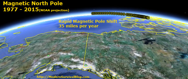
8. The magnetic North Pole
of the Earth is moving
northward at a rate of
10 miles/hour.


9. There is a belief by the
 scientist that Earth may
have had two moons
at some point of time.
10.  But some seem to approve
 that Earth has two moon’s
because now and then there
is an asteroid that gets sucked
 into our orbit and keeps sticking
 around for a continuous 9 months.


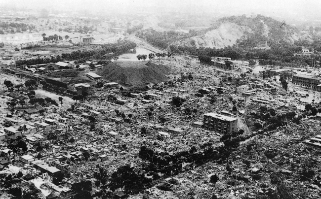
11.  Earthquakes are not
the only quakes that cause 

changes in the  Earth. The Moonquakes 
 also make a good difference by affecting 
the tides of the oceans 
and seas.
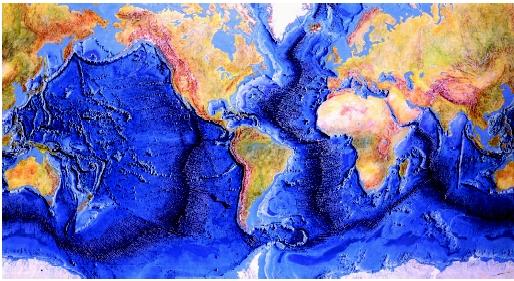
12. The world’s longest mountain
range is the one underwater.
It is called the Mid Ocean
Ridge System. It is 80,000 km
 long which goes around the
world and is 20 times
longer than the longest
mountain range on 
the surface
 of the Earth (The Andes) and
all the mountains are volcanic.


14. The oceans cover about 70%
of our surface but we have
explored only 5% of them.
13. The most active volcano in
the wo
rld is the Stromboli Volcano
in Southern Italy because it has been
erupting almost continuously for the
past 2,000 years. It has been rightly
 nicknamed as “The Lighthouse
of the Mediterranean.”


15. Made-up of millions and millions
of tiny polyps, the Coral reefs are the
 largest living structures on Earth and
some can be seen clearly from space.

OCEANS OF THE WORLD - INTERESTING FACTS

      Earth is truly nicknamed at the “Blue Planet” because there is no other planets know to have so much of water. The word ocean comes from Oceanus, who in Greek mythology was the son of Uranus, god of the sky, and Gaea, goddess of the Earth. Oceanus was also the river they believed surrounded the flat Earth. We have divided this huge water body into the Pacific, Atlantic, Indian, Arctic and Southern oceans, but in reality, they are all connected as one vast ocean.
FACTS ABOUT OCEAN WATER:
·         CLIMATE: The oceans affect climate as water warms more slowly than land, and cools more slowly than land, also islands and the coasts of continents have cooler summers and warmer winters than inland areas.
·         SALT: on an average, each liter of water contains about 35 g of salt, although shallow, warmer seas are usually saltier.
·         LIGHT: Sun light allows plants to grow underwater to a depth of about 200 m. below this, the waters get darker the deeper you get and plants cannot grow.
·         PRESSURE: The deeper you go in the sea, the more pressure or squeezing force, there is.
·         TEMPERATURE: the surface temperature of tropical seas is about 250 C, and in most other seas about 170 C in summer and 100 C in winter. The temperature at the bottom of the ocean is 20 C.
·         SOUND: Sound travels at a speed of 1,531 m per second under water – four times faster than it does in the air.

DIFFERENT ZONES OF THE OCEAN:
Our oceans are divided into different zones, depending on their depth. From the sunlit zone to the deepest depths, a variety of marine life can be found.
·         SUNLIT ZONE: Most sea animals live near the surface where there is lots of light. Fish live off plankton and in turn they are eaten by larger predators.
·         TWILIGHT ZONE: From 150 m to 1000 m it is known as the twilight zone. Many creatures living here produce their own light and glow, either to attract prey or scare predators.
·         DEEP OCEAN: Even at the greatest depths, 10 km below the surface, strange animals lurk on the dark sea floor waiting for dead things to fall from the waters above.

OCEANS: The Ocean’s deepest point is the Challenger Deep in the Mariana Trench, in the Pacific, at a depth of 11,034 m (36,200 ft). In the deepest trenches, springs of hot water, called black smokers, gush clouds of chemicals up to 4000 C from the seabed.70 % of the Earth’s surface covered by oceans and seas. 97% of the world’s water in the oceans – 2% is ice and only 1% is fresh water or water vapor in the atmosphere. There are about 30,000 islands in the Pacific Ocean. Some are the peaks of underwater volcanoes. The largest mountain on Earth is Mauna Kea, a volcano in Hawaii. At 10,205 m (33,480 ft), it is much taller than Mount Everest but most of it is underwater.
 THE FIVE OCEANS:
1.   PACIFIC OCEAN    : 155.6 million sq km (96.6 million sq miles)
2.   ATLANTIC OCEAN  : 82.4 million sq km (51.2 million sq miles)
3.   INDIAN OCEAN      : 73.6 million sq km (45.7 million sq miles)
4.   SOUTHERN OCEAN : 20.3 million sq km (12.6 million sq miles)
5.   ARCTIC OCEAN      : 14.1 million sq km (8.7 million sq miles)

SEAS: Seas have a specific feature and form a part of a larger ocean. They are shallower than oceans, with no major currents flowing through them. Seas have salt water, but names can be confusing. One of the world’s saltiest seas, the Dead Sea in Israel, is actually a lake because it is not connected to an ocean.
 THE FIVE SEAS:
1.   SOUTH CHINA SEA   : 2,974,600 sq km (1,848,300 sq miles)
2.   CARIBBEAN SEA       : 2,515,900 sq km (1,563,300 sq miles)
3.   MEDITERRANEAN SEA : 2,510,000 sq km (1,556,900 sq miles)
4.   BERING SEA             : 2,261,000 sq km ( 1,404,900 sq miles)
5.   GULF OF MEXICO    : 1,507,600 sq km (936,700 sq miles)

EARTHQUAKES - A SHORT NOTE

Why does the Earth quake?

 The surface of the Earth is like a massive jigsaw puzzle made up of huge rocky pieces called tectonic plates. The pieces of this puzzle are constantly moving about very slowly, but with immense force. If they slide past or crash into each other the Earth shakes and quakes. According to the United States Geological Survey, there are more than 3 million earthquakes every year. That's about 8,000 a day, or one every 11 seconds! Most of these are too weak to be noticed. Most earthquakes occur at depths of less than 80 km below the Earth's surface.


How do scientists measure Earthquakes?

     Scientists measure earthquakes in two different ways - by its magnitude or its intensity. Magnitude means the power of the shock waves and it's usually measured on the Richter scale. The Modified Mercalli Intensity scale measures the effects of an earthquake. 


What are the warning sign?

  Some people claim that you can predict an earthquake by spotting changes in some animals' behavior in the days before an earthquake.
  • Hens stop laying eggs.
  • Bees leave their hives.
  • Rats, weasels, and centipedes leave their homes in large numbers.
  • Dogs bark or whine excessively.
  • Flamingos abandon their low-lying breeding grounds.
  • Mass migration of toads to safer ground.

Cracks in the Earth:

THINGVELLIR RIFT, ICELAND
     In some places you can clearly see the cracks, called faults, at the edges of the Earth's plates.
  • THINGVELLIR RIFT, ICELAND: These exposed fault lines show the rift that lies on the boundary separating the American and Eurasian plates.
  • SAN ANDREAS FAULT, CALIFORNIA, USA: This is a strike-slip fault, which indicates that the rocks move sideways and in opposite directions.
  • GREAT ALPINE FAULT, NEW ZEALAND: This fault line runs almost the entire length of New Zealand's South Island and is visible from space.

Most famous Earthquakes:

    2003 BAM, IRAN
  1. 1755 LISBON, PORTUGAL:- One of the worst earthquakes in history was followed by a tsunami and many fires.
  2. 1906 SAN FRANCISCO, USA :- Fires following this massive quake left 3,000 dead and 20,000 homeless.
  3. 1964 ALASKA, USA :- This powerful quake lasted nearly five minutesand was followed by a tsunami.
  4. 1995 KOBE, JAPAN :- Lasting barely 20 seconds, this quake killed 6,400 people and caused US $ 200 billion in damage.
  5. 2003 BAM, IRAN :- The city's many mud-brick buildings were destroyed by this massive earthquake.

Most powerful earthquakes:

  • CHILE, 22 A: MAY 1960; Richter measure - 9.5
  • PRINCE WILLIAM SOUND, ALASKA : 28 MARCH 1964 ; Richter measure - 9.2
  • INDIAN OCEAN : 26 DECEMBER 2004; : Richter measure - 9.1
  • ANDREAN OF ISLANDS, ALEUTIAN ISLANDS : 9 MARCH 1957; : Richter measure - 9.1
  • KAMCHTKA, RUSSIA : 4 NOVEMBER; : Richter measure - 9.O

Deadliest earthquakes:

TANGSHAN, CHINA
  • SENSBI PROVINCE, CHINA : 23 JANUARY 1556; People killed - 830,000
  • TANGSHAN, CHINA : 28 JULY 1976; People killed - 242,000
  • KANSU, CHINA : 16 DECEMBER 1920; People killed - 180,000
  • TOYKO-YOKIHAMA, JAPAN: 1 SEPTEMBER 1923; People killed - 140,000
  • GULF OF CHIHLI, CHINA : 27 SEPTEMBER 1290; People killed - 100,000
  • CATANIA, SICILY, AND NAPLES, ITALY: 11 JANUARY 1693; People killed -  60,000(Catania) and 93,000 (Naples)
  • SHEMAKHA, AZERBAIJAN : 25 NOVEMBER 1667; People killed - 80,000
  • MESSIAN, ITALY : 28 DECEMBER 1908
  • KANSU, CHINA : 26 DECEMBER 1932 ; People killed -  70,000


MOUNT KENYA - SOME IMPORTANT FACTS

MOUNT KENYA – IMPORTANT FACTS AND FIGURES:-

ELEVATION: 17,057 feet (5,199 meters)

PROMINENCE: 12,549 feet (3,825 meters)

LOCATION: Kenya, Africa.

COORDINATES: 0.1512°S / 37.30710°E


FIRST ASCENT: First ascent on September 13, 1899 by Sir Halford John Mackinder, Josef Brocherel, and Cesar Ollier.

·         Mount Kenya is the second highest mountain in Africa and the highest mountain in Kenya. Mount Kenya, with an elevation rise of 12,549 feet (3,825 meters, is the 32nd most prominent mountain in the world. It is also on the Second Seven Summits lists, the second highest mountains on each of the seven continents.

·         Mount Kenya has several summits, including its three highest peaks—17,057-foot (5,199-meter) Batian, 17,021-foot (5,188-meter) Nelion, and 16,355-foot (4,985-meter) Point Lenana.

·         Mount Kenya lies 90 miles (150 kilometers) northeast of Nairobi, the capital of Kenya. The mountain is south of the equator.

·         Mount Kenya is a stratovolcano that arose over 3 million years ago. Its last eruption was between 2.6 and 3 million years ago. The volcano rose as high as 19,700 feet (6,000 meters) before being eroded to its present height. Most of the mountain’s volcanic activity was from its central plug, although satellite craters and plugs indicate active volcanism in nearby areas.

·         Two extended glacial periods sculpted Mount Kenya. Moraines indicate that the lowest elevation the glaciers reached was 10,800 feet (3,300 meters). The entire summit was also covered by a thick ice cap. There are currently 11 small but shrinking glaciers on Mount Kenya. Little snow now falls on the mountain so no new ice forms on the glaciers. Climatologists predict that the glaciers will disappear by 2050 unless current temperature and precipitation changes occur. The Lewis Glacier is the largest on Mount Kenya.

·         Since Mount Kenya is an equatorial mountain, the day and night are each 12 hours long. Sunrise is usually about 5:30 in the morning and sunset is about 5:30 in the evening. There is only a one minute difference between the shortest day and the longest day.

·         The origin and meaning of the word Kenya is unknown. It is thought, however, to derive from the words Kininyaga in Kikuyu, Kirenyaa in Embu, and Kiinyaa in Kamba, all of which mean “god’s resting place.” The names of Mount Kenya’s three major peaks—Batian, Nelion, and Lenana—honor Maasai chiefs.

·         The first ascent of Batian, Kenya’s highest summit, was on September 13, 1899 by Sir Halford John Mackinder, Josef Brocherel, and Cesar Ollier. The trio climbed the southeast face of Nelion and bivouacked. The next day they crossed the Darwin Glacier and climbed the Diamond Glacier before climbing to the summit. Mackinder led a large expedition with six Europeans, 66 Swahilis, 96 Kikuyu, and two Maasai to the mountain. The party made three unsuccessful attempts in early September before success.

·         Mount Kenya is the centerpiece of Mount Kenya National Park and is listed as a UNESCO World Heritage Site for its unique geology and natural history. The mountain’s unique afro-alpine flora or plant life is considered an outstanding example of alpine evolution and ecology. Mount Kenya also has Dr. Suess-fantasy forests of giant groundsel and lobelia, as well as moors blanketed with giant heather and dense bamboo forests. Wildlife includes zebras, elephants, rhinos, antelope, hydraxes, monkeys, and lions.

THE MAJOR THREATS TO MT. KENYA'S ECOSYSTEMS :

The Mount Kenya ecosystem and unique natural resources are being degraded and in many cases destroyed by uncontrolled use and exploitation. The forests especially are under extreme threat from human induced illegal activities. Some of the major threats are listed here below:

·         Logging of indigenous trees
·         Charcoal production
·         Marijuana cultivation
·         Forest encroachment and squatter settlement
·         Poaching
·         Livestock grazing
·         Fire
·         Landslides
·         Corruption
·         Lack of sufficient funding for KWS, complacent policing of existing laws


CLIMBING MOUNT KENYA:


·         Mount Kenya is much more difficult to climb than Kilimanjaro, Africa’s highest peak. To reach the twin summits of Batian and Nelion requires rock climbing skills and equipment, whereas Kili only requires stout legs and lungs. Few climbers reach the summit of Mount Kenya every year. Besides being more difficult than Kilimanjaro, an ascent of Mount Kenya is cheaper since neither porters nor guides are required.

·         Climbing on Mount Kenya depends on the equatorial season and the position of the sun. The ice climbs on Kenya’s southern faces are best climbed when the sun is in the north from July to September. This season also offers the best rock climbing conditions on the north and east faces. When the sun is in the south from December to March, the southern faces are best for rock climbing while the north faces offer ice climbing conditions.


AURORA: A SHORT NOTE

WHAT IS AN AURORA?

Auroras — ever-shifting displays of colored ribbons, curtains, rays, and spots — are most visible near the north (aurora borealis) and south (aurora australis) poles as charged particles (called ions) streaming from the sun (the solar wind) interact with Earth's magnetic field.

HOW ARE AURORA FORMED?
When energetic charged particles enter the earth's atmosphere from the solar wind, they tend to be channeled toward the poles by the magnetic force which causes them to spiral around the magnetic field lines of the earth. They are energetic enough to ionize air molecules, so a considerable number of atoms and molecules are elevated to excited states. When they make the transition back to their ground states they emit light characteristic of the atoms and molecules. Red and green light emitted from oxygen atoms is a constituent of the light seen at the poles. Atmospheric nitrogen also plays a role. An example of the colors that might be visible can be found by observing the nitrogen spectrum. Near the north pole the light show is called the aurora borealis and near the south pole it is called aurora australis.

A polar satellite captured images of aurora over the South Pole of the Earth. UV photographs of Jupiter indicate that auroral phenomena occur in its polar regions. Images of Saturn aurora show a very active pulsating pattern.

COLOUR OF AURORA:
Auroras happen when ions in the solar wind collide with atoms of oxygen and nitrogen in the upper atmosphere. The atoms are excited by these collisions, and they typically emit light as they return to their original energy level. The light creates the aurora that we see. The most commonly observed color of aurora is green, caused by light emitted by excited oxygen atoms at wavelengths centered at 0.558 micrometers, or millionths of a meter. (Visible light is reflected from healthy (green) plant leaves at approximately the same wavelength.) Red aurora are generated by light emitted at a longer wavelength (0.630 micrometers), and other colors such as blue and purple are also sometimes observed.


POLAR AURORA:
Alaska is known as a good place for seeing the polar aurora, also known as "Northern Lights." Originally the phenomenon was named "Aurora Borealis," Latin for "northern dawn," since in the lower 48 states or in mid-Europe it may appear (on the rare occasions when it does) as a glow on the northern horizon, as if the sun was rising from the wrong direction. But the southern hemisphere has the same phenomenon, with the glow coming from the south, so scientists prefer to call it simply the "Polar Aurora."

    Most visitors to Alaska never get to see an aurora, because they come in the summer, when skies are rarely dark enough. Alaskans claim that only around August 16 does the sky get dark enough to see stars, which is when aurora stands out. After that date, your best bet is to go to Fairbanks--and since the brightest auroras occur around midnight (or later, due to Alaska's time zone), you might have to stay up a long time. Perhaps it is better then to ask the night clerk at your hotel to ring you up if a good display becomes visible.

AURORA FROM SPACE STATION:
You've seen amazing images of the Aurora Borealis and its counterpart, the Aurora Australis here on Environmental Graffiti in the past, but now you have a chance to see them as never before: from space. If you think the view down on Earth is incredible beyond words, wait until you see what these natural light phenomena look like from the International Space Station and through the lens of the Hubble Telescope.